Thursday, October 20, 2016

Just a Be Toll To The Ground Of What is Political On Earth With A Plan It As The Fare Row To A Singing As We Row???


As Wares to the logic on the throat of relief is the advance to understanding logic. The companion to such degree of education is as the audio to the event. In comprehension of great touching only the shoulder of carriage it is as the forest clears to no grove or filled in magic. The basis of cover is width to the Times at Ages in the history of historical time-line to the various studies of library on true. To be of sleeve with a footprint to birth an that best of show to my upbringing. I appreciate all of the shown, as by that the lesson in life has been such a treasure of grown.

The spacial recognition of surrounding at the precious value of seen to advise the connection to the evolution of this ground to the discovery of great passion of what is the encyclopedia hidden in the avenue of the brain and its aspect to design. For matter in the subject of the sciences, a light year and the Milky Way have been fine draws to the exploration of I in a single sleep to see the soaring of what is compass to a dreams flight. In the excitement of wonderful shine the sunrise at dawn and coffee in hand for the diner is of what is strength to better than a religions supper of death at the hell of what humanity loves to embrace.

Across the section of just more on the grands is to balance this with the scenery of Mankind in its etch to wisdom and in also the horror of its habit to destroy. As witness to such vacuum the space and its black holes, what a describe would satisfy people would be only the real of what is a day. The calendar for the measure to the thousands of years on religious robbery is more than the example as religion just gauges the varied rumbles on the knowledge that comes to any on a shore that regards more to life than the dead to live social perhaps. In that is the actual on the reality of the country of my birth as the harbor of elections has shown a retraction or an attraction to return to the dark ages in its moral and principle of government. In that is the advance of what is history on a repetition from the ankles to that Cross as the shift to what has already gone to the belly of the stomach of a scorched earth. To bring more than an envelope, rather to break the seals is to be on a letter as this write.

I believe?? No, I am aware of more than the leveling of ground to bring just more control to the countries at the bevel of a contingency that shakes the pours to pitch a dead world of drones and cost. To build on structure and construct more than a body and a make the slavery a gene, I virtue this entire parade to the desperate method of systems stymied in the religions to event nothing more than the next rooster to cock the hen house of Mankind with further down feathers to be at the benches of what is a skull to the mind in the brain of historical fashioning.


To stride a cadence with discipline and harness of a bit to the language of rein is to in the whistle not blow a stance of perhaps. The happened has in deed harp to the Ages in Time, and that is fact. The planks and the drownings, the deaths for the God of whom keels fashion to that address has far out-weighed any foremost growth to the Human Being and common sense. Divide even that math to the Ancient Alien theorists on the Discovery Channel and their belief in the U.F.O. And the alien provide itself offers nothing other than the big shamble from the sky that somehow magically is leaning on spy of humanity to further the growth of minds to event success in the long shores. It is all so related that how a person could logically say that is is not the same would be as the turtle did not swim the ocean tides. At that the spin to modern day is arithmetic to add the venture as humanity just changed Latin to English and the World begins the entire repeat of chaos again on the hemming way (said for apropos expletive bringing the Republican Candidate and his explain of his Twitter Accounting and how it is also the name of the street that my mother, older sister, older brother and I all lived on in San Francisco just before we all moved to 815).

Thursday, October 13, 2016

The Astrolabe Is A Very Ancient Astronomical Computer


The staggering shelf of what Humanity or Mankind has library to in course to understanding the human mind as in result I have corked much thought to such and yet found to scratch the encylopedia of such must sway to only say the defining or definition of the computer in and of itself.  As the computer is in mechanics production of the human brain it parts fathom to reality as people just jumble the connection to shingle.  At say to process the human mind is gathered to real aspect of the look to that technology and that receipt of register puts to case of the library a booking.  In chapter however the verse has been lost to thought of expand connection to a port and not the ocean of its ability to the girth of each person as capable. Strange happenings.

The photograph or older fashion word of capture in a still would in seen say that belief of advancing is not faith but the very tangible expand of resident to individual.  In staff of example the computer at connection in a single screen would portion the human being at blink or blinking.  To saddle with less would raft the builders of such fantastic machines to what is the storage capacity settled for.  The growth of nature to lazy these products to examine an article as a parade to dismiss their varied variables is in Science shown that the Human brain is only at a 10 percent address.  Therefore the example in and of just numbers on the percent of the grounding of these fractions should or should have caused the harbor of Humanity to popular the brain as a wonder to the very library of history and the gene.  As should the variable add just and only incarnation or reincarnation as a arithmetic metric the math would indeed bring even greater to the equator of the balance at incredible in the sciences of true reality.  Due to the fork of earth on the screen of deny to many religions and or beliefs of different duck to quill these simple averages have been thrown to the doves and pigeon is seemingly the only goose cart of message.  To true course of chart on vast oceans it is as an era of the 'flat world' harness to the in-happened expanse to the U.S.A. finding in some 200 years ago new found land.

Trim to shipping of a difference yet on the same in charge it brings concept to that magnet of the compass that found to ship back in the day of adventure to sailing the oceans originally. Navigation wide to the universe and stars as galaxy search in depth of night brought many a ship to new shores, yet in the late 1500's and forward the compass of man brought delivery to more substance of the gear of machining ( https://en.wikipedia.org/wiki/History_of_navigation ) and with such there is still finding that humanity and or mankind will further concept to the above.

For reference in the halting language and that fill is styled to only numbers I put to sand that words do enhance to Mountain and therefore are more easily ready to distribute the connection from a single drop of rain and or a single snowflake as the natural candor to cadence this concept as the character of carriage to harness not in philosophical but in real.  As the creek does river to a dam.  The water does raise to flood.  The flash is a bulb of a camera and/or a flood and therefrom the blink of the eye can deed to provide mind to brain to stomach the gut as the naturally found or for the finding.


To dutch crunches for method to discovery of historical facts for evidence to support information on the written text of not conception, rather reality.  These to bit to the gather the of language to support fashioning of address.


Navigation of the American Explorers - 15th to 17th Centuries

Seventeenth century travelers to Maine’s coast such as Samuel ChamplainGeorge Waymouth, and John Smith carried state-of-the-art navigation tools for both dead reckoning and celestial navigation.

Navigation Tools for Dead Reckoning and Piloting

Invented in China in the 3rd century BC, the compass did not come to Europe until the 12th century AD. By the time of Columbus' voyage it was common. Instead of degrees, thecompass card, on which directions were drawn or printed, showed the points of the compass, including north, south, east, and west. There are 32 points of the compass, the four main quadrants of the circle each divided into eight 11¼ ° points. Columbus noticed that, as one sailed across the Atlantic Ocean, the variation between magnetic north andtrue north changed. On future trips he used this to predict, roughly, his arrival in America.
Dry Card Box Compass
Points of the Compass

A Chip Log, a Log Line Reel, and a Sand Glass

The next most important tool was the chip log, introduced in the late 16th century to measure speed. The chip, a quarter circle of wood, was attached to a light line on a reel. Knots were tied at 47' 3" intervals, the distance the line would be pulled out in 28 seconds if the ship’s speed was one knot or nautical mile in an hour, when the chip was dropped overboard. With a 14- or 28-second sand glass, navigators could see how fast the vessel was going by counting how many knots rolled out before the sandglass expired. Before the chip log, navigators estimated speed by timing how long a chip of wood in the water would take to pass from bow to stern.
Traverse Board
Traverse Board
Certaine Errors in Navigation

Compass and log helped navigators keep track of position. They used a lead line to determine water depth and bottom type. A heavy piece of lead at the end of a long marked line had a cavity in its bottom, which, when coated with grease or tallow, brought up a bottom sample. Experienced navigators often could determine position based on whether the bottom was muddy, sandy, pebbly, rocky, or covered with vegetation or shell fragments. Crossing the Atlantic, navigators used the lead line to find the continental shelf, and, more importantly, find the Grand Banks and other fishing grounds.
Wright's Chart of the World, 1599

To record a vessel’s courses and speeds, the navigator used a traverse board. The board had a line of holes radiating from the center towards each of the 32 compass points. Sailors inserted pegs in the holes to show the vessel’s course and speed each half hour. The navigator then used traverse tables to add these and give an average course for a four hour watch. This result then was entered into a logbook along with information about the weather, changes in sails, and items concerning the crew.

Guides for the Navigator

The seventeenth century navigator had little published information. Charts were rare; some advanced navigators carried globes. Mercator projection charts were far more useful than earlier charts. With its mathematical errors corrected by Edward Wright in 1599, the Mercator projection chart allowed mariners to draw a rhumb line between two points, get a bearing and sail that line.
The Mariners Mirrour, 1588
The English Pilot, Fourth Book

The earliest sailing directions originated in the Mediterranean as manuscripts calledportolanos which were first printed in the second half of the sixteenth century. The first important collection was published in 1584 by the Dutch pilot Waghenaer. These volumes, with charts, sailing directions, navigational instructions, and tables, became known in England as "Waggoners" In 1671, the first of four volumes of The English Pilot appeared, based mostly on Dutch sources. These covered Europe, the Far East, and North America.

Seaman's Quadrant

Seaman's Quadrant

Tools for Finding Latitude and Time

The only way navigators could estimate a vessel’slongitude was by dead reckoning and measuring variation. Celestial navigational instruments were designed to help find a vessel’s latitude, the approximate time, and the direction of true south.
The quadrant, the earliest device used to find latitude, was a quarter-circle of wood, marked in degrees, with a plumb line and a sight along one edge, first taken to sea around 1460. Another early latitude-measuring device is the astrolabe. It is a disc with degrees and a movable arm with sights, first known to be at sea about 1481.
Astrolabe Diagram
Astrolabe Diagram
The Method of using an Astrolabe

In the 15th century, Portuguese Prince Henry the Navigator pioneered nationally sponsored exploration and cartography. Portuguese navigators apparently took the cross staff to sea about 1515. It has two parts: a long graduated staff and a sliding crosspiece.
Cross Staff reproduction
The Method of using a Cross Staff

The navigator holds one end of the staff near his eye, where both the sun and horizon may be sighted, and then moves the crosspiece along the staff until one end is lined up with the horizon and the other with the sun or star. The angle is read from the scale on the staff. The cross staff required the navigator to look directly into the sun, almost impossible in bright sunlight. But it could be used when the ship was moving, and it was simple and relatively inexpensive.
Backstaff reproduction
The Method of using a Backstaff

Nocturnal, George Waymouth

A variation of the cross staff is the backstaff, invented byJohn Davis about 1594 and published in his Seaman’s Secrets in 1595. With it a navigator could measure angles accurately without looking directly at the sun.
The backstaff, in its final form, was made of wood and was made up of two arcs, a larger 30° arc and a smaller 60° arc.Vanes allowed accurate sighting of the horizon, while the sun showed a shadow on another vane. Also called a Davis quadrant, it could only be used for sun sights.
At night, navigators could tell time using a nocturnal, a device that measured the angle from the North Star to the pointer stars, either in Ursa Major (the Big Dipper or Big Bear) or in Ursa Minor (the Little Dipper or the Little Bear). It used the vertical as a reference, and required the month and date to be set. A sundial could be used in daylight.
Gunter's Scale
Gunter's Scale (detail)

By the middle of the 17th century, thanks to the invention of logarithms by John Napier which were transformed into a simple calculator by Edmund Gunter, navigators with little mathematical training could solve trigonometric navigational problems.
By the end of the seventeenth century, navigators were able to tell time within a quarter of an hour and find their latitude within a few miles. Despite their relatively simple instruments, these mariners sailed the globe.

Navigation and Related Instruments in 16th-Century England

By the dawn of the sixteenth century, the ancient art of navigation had begun to develop rapidly in response to oceanic explorers who needed to find their positions without landmarks, to determine the locations of their discoveries, and to establish routes between the new-found lands and home. Although the relationship of certain heavenly bodies to time of day and terrestrial directions had been known since ancient times, the first two decades of the sixteenth century saw the rigorous application of astronomy and mathematics to navigation. The new learning met the New World.
 
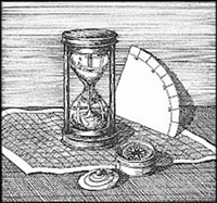
This drawing shows some important navigational tools, including a compass, an hourglass and a quadrant.
Tools such as an hourglass, a quadrant, a compass and a nautical chart were vital for effective navigation.
Vicki Wallace
Navigation is based largely on the spherical coordinates latitude -angular distance north or south of the equator - and longitude - angular distance east or west of a generally accepted reference location, such as the Greenwich Observatory. Finding longitude requires comparing local time, measured by a heavenly body, with the local time at a reference location, kept by a clock. Mechanical time-pieces existed in the Elizabethan era, but until the late eighteenth century they had to be corrected frequently by sun sightings and were therefore almost useless aboard ship. Measuring latitude, on the other hand, does not require an accurate time-piece. Refinement of instruments enabled sixteenth-century mariners to determine latitude with reasonable accuracy. Latitude was therefore extremely important to Elizabethan navigation.
Unable to use the latitude-longitude system to the fullest, sixteenth-century navigators supplemented latitude with a rho-theta (distance-and-bearing) system - dead (from deduced) reckoning. Beginning at a known or assumed position, the navigator measured, as best he could, the heading and speed of the ship, the speeds of the ocean currents and the leeward (downwind) drift of the ship, and the time spent on each heading. From this information he could compute the course he had made and the distance he had covered. Dead reckoning, through educated guesswork, is often very accurate. It is still practiced on ships and aircraft, and it lies at the heart of modern doppler and inertial navigational equipment. Errors tend to accumulate in dead reckoning, so its accuracy depends in part on the length of the voyage and the ability of the navigator to use latitude and other information to limit error. But above all else, dead reckoning depends on reliable instruments.
 
Instruments For Measuring Latitude
The celestial globe was a mounted sphere depicting the heavens instead of the earth. While many were designed to grace private libraries, some were used as navigational instruments. With the introduction by Gerardus Mercator, in 1569, of practical, affordable sea charts, on which were shown parallels of latitude and meridians of longitude, the costly and delicate celestial globe gradually fell out of use.
 
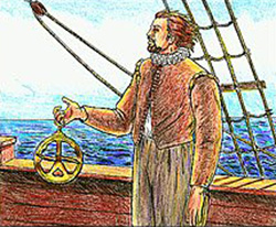
A man carries an astrolabe on the deck of a ship.
It could be difficult to use an astrolabe when on a ship's deck.  It required precision that could be difficult on a rocking ship.
Vicki Wallace
The astrolabe was used to determine latitude by measuring the angle between the horizon and Polaris, also called the North Star, the Pole Star, or Stella Maris (Star of the Sea). Polaris was the preferred star for measuring latitude because it is less than one degree from the north celestial pole (the point in the heavens directly above the geographic north pole).
The astrolabe is an instrument of some antiquity; Persian models dating as far back as the eleventh century have been found, and Chaucer wrote a Treatise on it in the late 1300s. By the Elizabethan era it consisted of a large brass ring fitted with an alidade or sighting rule. The user held the astrolabe by a loop at the top, turned the alidade so that he could sight the star along its length, and read the altitude off the scale engraved on the ring - difficult tasks to perform on the deck of a heaving ship. The consequences of imprecise measurement are serious (a latitude reading just one degree off produces an error in position of 60 nautical miles), so mariners often used the astrolabe in pairs, one to sight along the alidade, the other to steady the instrument and take readings. On shore, however, the astrolabe was easier to use and more accurate.
The quadrant, shaped like a quarter-circle, was another hand-held instrument of wood or brass. The user measured the altitude of Polaris by sighting through a peephole and taking a reading where a short plumb line intersected the scale on the outer edge of the arc.
The cross-staff had developed from the tenth-century Arab kamal. It consisted of a square staff 3.5-4 feet in length, bearing a scale, with four sliding cross-pieces or transversals of graduated lengths. Only one transversal was used at a time, its selection being based upon the height of the heavenly body in the sky - the higher the body, the longer the transversal. The user held on end of the staff to his eye, then slid the transversal onto the far end and moved it back and forth until its upper and lower edges seemed to touch, respectively, the observed body and the horizon. The location of the transversal on the scale was converted by a table into degrees of latitude.
Polaris is often obscured by clouds, fog, or daylight, and it is below the horizon for anyone in the Southern Hemisphere. Darkness often makes the horizon hard to find. So navigators learned to use the astrolabe, quadrant, and cross-staff with the sun. A piece of smoked glass was frequently used to keep the user from blinding himself. Under lock and key, for use by the captain and pilot only, were highly prized declination tables or astronomical charts showing calculated heights of the sun above the equator at noon for every day of the year.
The Magnetic Compass
The foregoing instruments provided invaluable information, but their use depended on the visibility of heavenly bodies. As a result, mariners relied on the magnetic compass, an instrument developed, probably independently, by Chinese in the eleventh century and Europeans in the twelfth. Day or night, fair weather or foul, Northern or Southern hemisphere, the compass always points more or less north. At first compasses seem to have been used mainly to measure wind direction, but mariners soon found them much more beneficial when used for finding headings.
A typical sixteenth-century compass consisted of a large magnetized needle fastened to the underside of a circular card on which the several directions were drawn. The compass rose, as it was sometimes called, usually had thirty-two points 11.25 degrees apart - north, north by east, north by northeast, and so on. (Sailors learned early in their careers to "box the compass," that is, recite all the points in order.) The needle was pivoted on a fine brass pin to enable it to swing freely. The compass card was suspended by gimbals (concentric mounting rings), which allowed the card to remain level regardless of the motion of the ship. The mechanism was kept in an open-topped box attached to a small cupboard called a bittacle (later binnacle), which was fixed to the deck in front of the helm. A lodestone, or piece of naturally magnetic iron ore, was used to re-magnetize the compass needle.
Christopher Columbus said that the compass "always seeks the truth." Unlike the modern gyroscopic compass, however, the magnetic compass does not always seek true north. The magnetic pole is not at the top of the world, but an ever-changing distance away in the Canadian Arctic. Local variations in the magnetic field of the earth produce different errors at different spots. This fact was recognized in the fifteenth century. The North Star gives a good approximation of true north, so compass variation was easy to measure even in the Elizabethan era. Instructions for an Atlantic voyage planned by Sir Humphrey Gilbert in 1582 list many pieces of navigational gear, including "An instrument for the variation of the compass." In his "Briefe and True Report" (1588), Thomas Harriot, chief scientist for the Lane colony (1585-1586), mentions "Mathematicall instruments," which undoubtedly included such a device. Some mariners mounted the needle on the compass card so as to take local compass variation into account and make the card indicate true north. This practice caused problems, especially when mariners tried to sail unfamiliar vessels or when coasting vessels made transoceanic voyages. (Compasses adjusted for the easterly variation found in Great Britain, for example, gave unsatisfactory readings in parts of North America with westerly variation.) Using several interchangeable cards with needles mounted at different angles for different degrees of variation did little to reduce confusion.
 
Instruments For Measuring Time
Accurate time is essential to dead reckoning. Water-clocks (clepsydras) and portable sundials suffered obvious disadvantages aboard ship, so the sandglass or hourglass was the timepiece most often used in navigation. The most common glasses were the four-hour and half-hour sizes. Days at sea were divided into six four-hour shifts or watches. A ship's boy carefully tended the half-hour glass, turning it as soon as the sand had run through and calling out or striking a bell for all aboard to hear. At the end of four hours, he turned the four-hour glass. (Hence the system of bells and watches still used aboard many vessels.) The texture of the sand could affect its rate of flow, as could condensation within the glass, so several glasses were used together for accuracy.
The glass was used in combination with the log, a piece of wood attached to a line knotted at uniform intervals. A sailor heaved the log from the stern of the ship and let the line pay out freely as the ship pulled away. When the sailor felt the first knot pass through his fingers, he shouted a signal to another sailor, who turned a one-minute glass. The first sailor counted aloud the number of knots that passed until the sand ran out. A timer of one minute (one-sixtieth of an hour), knots spaced one-sixtieth of a nautical mile apart, and simple arithmetic easily gave the speed of the ship in nautical miles per hour ("knots").
The nocturnal consisted of two concentric plates of brass or wood, the larger divided into twelve equal parts corresponding to the months of the year, the smaller into twenty-four parts corresponding to hours of the day. By lining up a sighting mechanism with Polaris or certain stars in Ursa Major or Ursa Minor, the user could determine the time of night with reasonable accuracy.
Other Tools
Charts not only gave the mariner an idea of where he was going, but also a means of plotting his past and present positions. Cartographers and mariners endured many of the same problems, such as inability to determine precise longitude. Consequently, most sixteenth-century charts were not very accurate by modern standards. To make matters worse, cartographers often copied from one another, used information from unreliable sources, and relied on their own imaginations to fill in gaps in coverage.
The traverse board was used to approximate the course run by a ship during a watch. It consisted of a circular piece of wood on which the compass points had been painted. Eight small holes were evenly spaced along the radius to each point, and eight small pegs were attached with string to the center of the board. Every half-hour one of the pegs was stuck into the next succeeding hole for the compass point closest to the heading the ship had maintained during that half hour. At the end of that watch, a general course was determined from the position of the pegs. With speed information from the long and line, the traverse board served as a crude dead-reckoning computer reminiscent of those used to this day aboard aircraft.
Used to find depth and sea-bed characteristics, the lead and line was an ancient, but highly useful navigational aid. It consisted of a sounding lead attached to a line with evenly spaced knots or bits of colored cloth worked into it. The lead was tossed overboard and allowed to sink to the sea floor. Each mark was distinctive, and the distance between successive marks was constant; so water depth could easily be measured ("by the mark") or estimated ("by the deep"). When hauled aboard, the lead, by virtue of tallow packed into a small depression in its bottom, brought up a sample of the sea bed, useful in finding a safe anchorage.
Albeit not a navigational instrument, the boatswain's pipe was a tool of great value. This peculiarly shaped whistle was used by the boatswain (the contraction bos'n was not used in the 16th century) to pipe orders throughout the ship. Its high-pitched sound was usually audible, even above the howling of the wind, to crewmen working high in the rigging.
The ship's log contained a record of courses, speeds, soundings, and other relevant information. A good log was sufficiently accurate and comprehensive to allow the navigator to check his dead reckoning.
Credits:
Text by Olivia Isil; edited and expanded by lebame houston and Wynne Dough
Illustrations: Vicki Wallace

Wednesday, October 12, 2016

Is The U.S.A. A^Ware Of A Civil Tongue Or Is It Just The E!^Trade A^Count In The Aspiration Of It's Masque^Caw^Raid??????


The Founders of the United States of America on the Constitution and the Declaration of Independence and the Museums to whom hold the scrap papers that have been quoted so heavily the vault of people must be the mined in October 2016.  Process to verbal announcements in the populus have grained sorted files to average the Middle Ages, strike the Catholic Church with a remainder fee of what is the posture of tongue to language on the chair of system to method Religions all over the world forests.  In that the fact that history case to study based comes in theme to trail a signature piece.  As the chorus goes to lyrics of policy?? The template of morals?? The morsel of what is define?? Creasing the hemming to way or path drank dined??

Treat to trial is what in the faxed of humanity to these counters of desk to the real eyes people are now proposing to drive the gears of mankind to the corner crevice of dark courts and benches that chair??  That Renaissance to chart the measure of thickness to the plank that tied the drowing in a cent??  Money for the belt of a back too??  Than the procession must lean to furnace or the few nor role of nails and byte??

A note to the actual form of political shards that have sliver to the American must in-hand dry the lung to pierced in brought down by feather of the sync.  As each fallow grains does the mill hull or haul lo??  Grand banks to eruptions are as the Wall Street seeks to balance a brazier to the Chest of Pea Pods and soy in the mile of what is a word.  Paragraph a tinfoil actual to the sword of forge and that dollar must wink to the religious root.

In depth to file the chart of ocean as the find of land touching what echo from the cliff note to why is there vaults to say that the Constitution had Men in the room and not an Elephant for looks.  In that is the country flinging pens to ink as the wall of persons method grants verbal a salt to the pep per ring of Twitter clam??


Cobble (geology)

From Wikipedia, the free encyclopedia
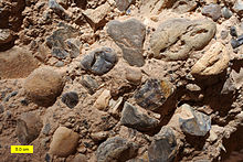
A rock hammer rests atop a variety of well-rounded gray cobbles.
Beach cobbles (Nash Point, Wales)
cobble (sometimes a cobblestone) is a clast of rock defined on the Udden–Wentworth scale as having a particle size of 64–256 millimeters (2.5–10.1 in), larger than a pebble and smaller than a boulder. Other scales define a cobble's size in slightly different terms. A rock made predominantly of cobbles is termed a conglomerateCobblestone is a building material based on cobbles.

Etymology[edit]

Cobbles, also called cobblestones, derive their name from the word cob, meaning a rounded lump. The term is further related to the German Kopf, meaning head.[1] Chester Wentworth referred to cobbles as cobble bowlders [sic] in his 1922 paper that would become the basis for the Udden–Wentworth scale.[2]

Classifications[edit]

A brown-gray cobble conglomerate
Sandy conglomerate with cobbles in the Hazeva Formation (Miocene) of southern Israel
Within the widely used Krumbein phi scale of grain sizes, cobbles are defined as clasts of rock ranging from −6 to −8 φ. This classification corresponds with the Udden–Wentworth size scale which defines cobbles as clasts with diameters from 64–256 millimeters (2.5–10.1 in). On this scale, cobbles are larger than pebbles which measure 4–64 millimeters (0.16–2.52 in) in diameter and smaller than boulders, whose diameters range from 256–4,096 millimeters (10.1–161.3 in). On the Udden–Wentworth scale, an unlithified fraction of cobbles is classified as gravel while a lithified sample primarily composed of cobbles is a conglomerate.[2] The Committee on Sedimentation of the US National Research Council has recommended that in situ cobbles be identified by their process of origination, if possible (e.g. cobbles by disintegrationby exfoliation, etc.).[3]
In the late 1800s and early to mid-1900s, prior to the Udden–Wentworth scale's widespread adoption, size classifications tended to group all particles larger than 2 millimeters (0.079 in) together as gravel or stones. Other scales have defined the size of a cobble slightly differently than the Udden–Wentworth; the British Standards Institution denotes a cobble as any clast ranging in diameter from 60–200 millimeters (2.4–7.9 in) while the United States Department of Agriculture's definition suggests a range of 75–250 millimeters (3.0–9.8 in) and the ISO standard 14688 names cobbles as ranging from 63–200 millimeters (2.5–7.9 in) in diameter.[4]
Various attempts have been made to refine the Udden–Wentworth scale, including its definition of cobbles.[4] In 1968, D. J. Doeglas proposed subdividing the cobble designation into two fractions, small cobbles (for particles with diameters from 64–125 millimeters [2.5–4.9 in]) and large cobbles (for particles with diameters from 125–250 millimeters [4.9–9.8 in]).[5] A 1999 paper by Terence C. Blair and John G. McPherson argued that the Udden–Wentworth and Krumbein scales betrayed a historical emphasis on the study of sand grains while ignoring larger gravel grains. They proposed defining fine cobbles as those with diameters from 64–128 millimeters (2.5–5.0 in) (−6 to −7 φ) and coarse cobbles as those with diameters from 128–256 millimeters (5.0–10.1 in) (−7 to −8 φ).[2] In 2012, Simon J. Blott and Kenneth Pye suggested that the cobble designation be eliminated altogether, replaced by very small boulder and small boulder designations equivalent in size to Blair and McPherson's fine and coarse cobbles, respectively.[4]

Settings[edit]

When occurring in streams, cobbles are likely to be found in mountain valley streambeds that are moderately steep.[6] Cobbles are also transported by glaciers and deposited as with other grades of sediment as till. If the till is water-laid, finer particles like sand and pebbles may be entirely washed away, leaving a deposit of only boulders and cobbles. Glacially transported cobbles tend to share several identifying features including a tabular shape and downward diagonal striations on lateral facets.[7]
Cobble conglomerates may be alluvial in origin or the product of "stone avalanches", a type of debris flow resulting from unconsolidated cobbles and gravel.[8] In such stone avalanches, well-rounded cobbles may travel the farthest on account of their low rolling friction.[9] When the product of alluvial processes, the cobble conglomerate's matrixconsists of gravel and coarse sand. In contrast, the matrices of flow-deposited conglomerates are primarily mud.[8]